GPX Routes
Here you will find GPX Route files for some great Peak District walks, I’m currently developing this page but for now please help yourself to the files below.
The 9 Edges Challenge
|
[wpdm_file id=5] |
| The 9 Edges Challenge is a big 24 Mile day that takes in Derwent, Stanage, Burbage North, Burbage South, Froggatt, Curbar, Baslow, Gardoms and Birchen Edges. Find details about my walk by visiting Peak District – 9 Edges Challenge |
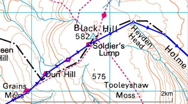
Black Hill from Crowden
|
[wpdm_file id=1] |
| A GPX File for my route from Crowden leading up and down Black Hill, visit the blog entry at Peak District – Black Hill from Crowden |
Ladybower Loop – Small Version
|
[wpdm_file id=8] |
| This another one of my track logs from the Peak District. The walk starts at the Ashopton Viaduct goes via, Wheel Stones, Dovestone Tor, Back Tor, down Green Sitches, then to Fairholmes. I then walked back to the Viaduct along the path at the side of the road. Peak District – Ladybower Loop – Small Version |
Wild Camping – Axe Edge Moor
|
[wpdm_file id=7] |
| This is the track log from my recent Wild Camping trip in the Peak District. I set off from Flash then go via Three Shire Heads, the Cat & Fiddle, Shining Tor, Cats Tor, Errwood Reservoir in the Goyt Valley, Berry Clough and then camp on Axe Edge Moor. I returned to Flash the following morning. Peak District – Wild Camping – Axe Edge Moor |
Howden, Bleaklow & Alport
|
[wpdm_file id=2] |
| A great route starting from Howden,following the river Derwent and then climbing up on to Bleaklow Stones. Then looping back around via Alport. Peak District – Howden, Bleaklow & Alport |
The old style list of GPX files is below
{wpdm_category=peak-district-gpx-files}
