A Wild Camp on Kinder Scout with my daughter. We parked the car in Hope and set off along the roman road towards Hope Cross, we then headed up to Crookstone Knoll on Kinder Scout for a relaxing night enjoying the views. We had a great night and the sunrise in the morning was amazing even if though it was a little cloudy. I was using a Wild Country Zephyros 1 Lite and my daughter had my standard Wild Country Zephyros 1.
Episode 9 of the Peak Routes Podcast features a walk in some excellent wintery conditions. I headed to Win Hill & Hope Cross in the Snow, it was a stunning day and I had great fun creating lots of media to share. I started at the Yorkshire Bridge Inn at Ladybower in the Peak District. I then head up to the top of a windswept Win Hill and through the snow drifts to Hope Cross. I then forge may way down through the forest and back along the banks of the Ladybower reservoir.
If you would like to download this episode or any of the others then you can visit the Podcast page of the site. You can also subscribe to get them delivered to you via Feedburner.
A walk starting at the Yorkshire Bridge Inn at Ladybower in the Peak District.I head up to the top of a windswept Win Hill and then through the snow drifts to Hope Cross. I then forge may way down through the forest and back along the banks of the Ladybower reservoir. View the blog post for this walk at Peak District – Win Hill & Hope Cross in the Snow.
Today’s walk was to be a relatively short one, I had limited time and I knew that my progress would be slowed slightly by the snow, the starting point was to be the Yorkshire Bridge Inn at Ladybower and thankfully the roads leading here were open today too. We have had a pretty heavy amount of snow in the last few days which has made a lot of roads impassable and many of the roads I used today were closed until 7am. Thankfully I managed to make it to the parking spot, getting kitted up and then get on my way without any problems.
Parkin Clough
Parkin Clough
The weather was stunning this morning, a very mixed bag with broken clouds and the odd snow shower. I made my way from the Yorkshire Bridge Inn towards Ladybower and then took the path along the dam wall. The path here had obviously seen a lot of traffic in the last few days as the snow was rather compact and it had turned pretty icy. Thankfully the fresh snow awaited me once I had crossed the dam wall and took the path that leads up Jaggers Clough. The last time I came this way was when I had Wild Camped at Wooler Knoll, walked down to meet my mate Andy at the pub and then walked back up and over to Alport Dale.
Parkin Clough
Parkin Clough Sign
The climb up through the forest at Jaggers Clough is sharp but thankfully rather short, I’m a sucker for a pine forest and it was looking nice today under a blanket of snow. The path was icy in places but nothing that would have required my crampons, the time passed quickly as I was concentrating on my footing and I reached the cross roads in what seemed like no time at all. From here it started to snow once again, I must have been the first person to come this way today as I had to cut a fresh through the artic landscape as I headed towards the tree line. The wind became much stronger as I reached the eastern flanks of Win Hill Pike to the point where huge snow drifts had formed, thankfully they were pretty manageable at this point so didn’t cause any problems.
Parkin Clough – Win Hill Plantation
Win Hill Plantation
The views from the top of Win Hill Pike were changing every 30 seconds or so, the snow was coming and going the every so often I would get a break in clouds. I don’t have a device that can measure wind speed or wind chill but it was pretty darn windy and cold up there today. I only stayed for a short while as the weather upped its game once again, the wind was whipping up the snow and the clouds were dropping a fresh covering. I headed off to continue my journey and noticed that the western edge of Win Hill Pike had turned in to one massive snow drift. The snow must have been 4-6 feet deep in places so I made sure that I stayed well clear once I had taken the a few images ☺
Win Hill Pike
Win Hill Pike
Win Hill Pike
Win Hill Pike – Trig Point
Win Hill Pike
Win Hill Pike
Win Hill Pike
As I made my way in a westerly direction I crossed sections of ice, drifts and patches where there was no sign of winter at all. The wind was whipping and swirling the snow in all directions until I eventually reached the relative cover of the Woodlands Valley Plantation. The snow at this point was around 2 feet deep, it was more suited to snow shoes today and I could picture Ray Mears in my mind as I forged my way towards Hope Cross.
Vale of Edale
Vale of Edale
Vale of Edale
Snow Drifts near Wooler Knoll
Walking near Hope Cross
The views from Hope Cross down the Vale of Edale were stunning once the snow had stopped and the cloud had broken. The sun came out to illuminate a spectacular winter wonderland and I decided that it would be the perfect time to have a spot of lunch.
Hope Cross
Hope Cross
While I was having lunch I met another couple of walkers who we from Norwich, they were staying at the Edale YHA and getting out everyday to enjoy the snowy conditions. They were the only people who I had seen so at that point and they seemed like really nice people. I spoke to them about ShareYourAdventure.com and also gave them one of the business cards that the creator Phil Sorrell supplied me with. I forgot to tell them about PeakRoutes.com though 🙂
Ladybower – Woodlands Valley
Ladybower – Woodlands Valley
After lunch I took the path from Hope Cross that heads down in to the forest, I had decided to take this route as I’d not walked this way before. On previous occasions I have headed along the roman road towards Alport and then picked up the path back to Ladybower. As my mission is to walk as many new routes in the Peak as possible I saw it as an opportunity to tick off another path.
The going was good through the forest although the path was rather tricky to follow in places due to the snow. When I came out on a freshly logged clearing I decided to ditch the path and head off piste straight down. The views along Ladybower from this angle are stunning.
Ladybower & Crook Hill
Ladybower
Ladybower
The route that runs along the southern edge of Ladybower is usually very easy, it follows a forestry track so the path is smooth and pleasant under foot. Today however the snow was around 1-2 feet deep as the accumulations hadn’t been whipped in to drifts like they had on higher ground. I pushed on through the snow while listening to the Bletchley Park Podcast.
Ladybower Sheep
I eventually made it to the point where the path swings towards the south and heads towards the dam wall. This section of path was very icy in places and I paused on a patch of snow to let a stampeding flock of sheep pass bye. I was in a world of my own gazing at views up towards Bamford Edge and I reached the road in not time at all. Al that was left then was to walk the final hundred or so metres back towards the Yorkshire Bridge Inn where my car awaited.
Ladybower & Bamford Edge
Thanks for stopping bye to read, view and listen to my exploits today. The YouTube video in this post was recorded and edited using my iPhone. A podcast version of this route will be available very soon on the Podcast page of the site, it will also be available from iTunes and many other podcast arching services via FeedBurner. Stay tuned.
I’m having a great run at the moment it seems when it comes to walking weather, I had checked the advanced forecast and selected Thursday the 13th of December to have a wander this week. When the day finally arrived I still hadn’t chosen where I was going to walk, I quickly checked my Dark Peak Combi Map on ShareYourAdventure.com and had a look what gaps need filling in. I decided to go for a walk I have done before but I haven’t tracked it while Social Hiking. I got all my cold weather gear ready, set up my map on ShareYourAdventure.com, loaded the car, made coffee and off I went.
A frosty start in Edale
When I arrived in Edale I was met by a beautiful winter scene, hoar frost, valley fog, and the sun piercing through the clouds into the valley. I managed to grab a parking space next to the school, put my boots on and then went over to the Old Nag’s Head to film a snippet of video for a short film I had planned to make during my walk today.
I had been planning on making this short movie for some time, one of those projects that I dream up in my head while at work and then take a while to get around to actually doing. sadly, a lot of my projects are still on the “to do” list but this one has made it through to completion 🙂
(function() { var po = document.createElement(“script”); po.type = “text/javascript”; po.async = true; po.src = “http://d15mj6e6qmt1na.cloudfront.net/assets/embed.js”; var s = document.getElementsByTagName(“script”)[0]; s.parentNode.insertBefore(po, s); })();
The views were stunning down in to the Vale of Edale as I climbed up towards Ringing Roger. The cloud was slowly dispersing and the sun was peeping out from behind Mam Tor to fill the valley with light.
Vale of Edale
Kinder Scout – Grindsbrook
Moors for the Future – Workers Tools
I spotted a couple of guys who were working on the footpath on behalf of Moors For The Future. They have been doing some great conservation work over the last few years, not only have they been building or repairing paths, they have been planting various things to help keep the moors in good condition. You can really see how the vegetation they have planted is taking hold and protecting the bare peat.
Ringing Roger on Kinder Scout
Moors for the Future – Bags of Rocks
Moors for the Future path work on Kinder Scout
Ringing Roger on Kinder Scout
The final part of the video was filmed up on Ringing Roger itself, I had envisaged myself looking out over a valley at the crescendo of the movie and this was a great spot to choose. The views from Ringing Roger are stunning as you look down to Edale and up Grindsbrook. The cloud was lingering at around 600 metres today so I had to go for a slightly higher shooting angle. The video itself was only really ever supposed to be a bit of fun, i’m hoping that a few more serious walking route videos will follow soon.
Kinder Scout Upper Tor
These 2 Bambuser Videos were being broadcast live while I was stood up there on Ringing Roger. The first one ends abruptly as I received a phone call, the second one ends after 9 minutes as my phone decided to switch off :-).
(function() { var po = document.createElement(“script”); po.type = “text/javascript”; po.async = true; po.src = “http://d15mj6e6qmt1na.cloudfront.net/assets/embed.js”; var s = document.getElementsByTagName(“script”)[0]; s.parentNode.insertBefore(po, s); })();
As I walked across towards Crookstone Knoll I witnessed a fantastic sight when looking down towards Hope Valley. The fog was rolling up the valley, it looked stunning as it was framed by Win Hill and Lose Hill. I recorded the AudioBoo above while I was stood there totally amazed 🙂
Looking down Jaggers Clough
Crookstone Moor
Crookstone Moor – PeakRoutes Logo Sign
I always like visiting Crookstone Moor, The sign post there has got to be one of my favourites now. I have kind of adopted it as the logo for PeakRoutes which means I look at it a lot now days, Its always nice to physically go back there and see it in person.
Roman Road to Hope Cross
Great Ridge looking from Bridleway near Hope Cross
I’m not sure which farm owns the land up here but they really do not want you to stray off the path. They have done everything than can to keep you “Off My Land” here. The Bridleway down to Edale and the Old Roman Road down to Hope is rather hemmed in.
Looking up Jaggers Clough
Jaggers Clough River Crossing
Jaggers Clough Bridleway
Win Hill and the Vale of Edale
Lose Hill looking frosty
By this part of my walk the skies were totally clear and the sun was streaming down in to the valley, Lose Hill looked impressive with its icy northern flanks and I even snapped one of the many trains running through the valley.
Bridleway from Hope Cross to Edale
It had been a great walk again today, infact every walk in the Peak District is great regardless of the weather. I would go out if it was chucking it down, I need to get my walking fix or all is not well with the world 🙂
Grindslow Knoll & Grindsbrook from Edale
I finished off the day by going for a pint of 1577 at the Old Nag’s Head. It was lovely and warm in there which felt very welcoming after being out in the sub zero temperatures all day. I got chatting with the lady behind the bar about history and she very kindly fetched a book for me to read. It was her copy of the History of Edale and it had a great wealth of information to soak in about the area. I have added it to my list of reading material to locate in the library the next time I go.
Edale – Old Nag’s Head
I headed back to the car after I had finished reading and drinking. I scraped the ice from the windows and then begun to drive home. I spotted a chap who was trying to thumb a lift at the entrance to the main car park in the village. I thought.. what the heck, i’ll give him a lift. I’ve never picked up a hitchhiker before and he turned out to be a thoroughly nice chap. He was a fell runner who had been out on Kinder researching routes for an upcoming fell race in January. I gave him a lift to Hathersage and we chatted about running, the Peak, the Lakes, Scotland and Snowdonia.
(function() { var po = document.createElement(“script”); po.type = “text/javascript”; po.async = true; po.src = “http://d15mj6e6qmt1na.cloudfront.net/assets/embed.js”; var s = document.getElementsByTagName(“script”)[0]; s.parentNode.insertBefore(po, s); })();
I’m hoping to be out again towards the end of next week, I shall bring you another bucket load of images, video and audio for you to sample. Thanks for stopping by and taking the time to read, watch, listen or just look 🙂
There are some times when just one day out on the hills just isn’t enough.. well.. I suppose one day is never enough really when I come to think about it. I have been doing lots of day walks in the Peak District lately so I thought it was about time that I chucked my tent in my bag and headed out for 2 days. As luck would have it I had 2 days spare so I consulted my mate Andy and a plan was set.
Andy decided that he could join me for 2 days of walking and I would Wild Camp alone inbetween as he had other commitments that night. We met up in Matlock yesterday morning at around 09:30, I chucked all my kit in his car and we made our way to Hope which was to be the start point of our walk on day 1. We had chosen to have another wander around the famous Edale Skyline Route which is a fantastic route which is ideal if you have a full day spare. We got on the way just after 10:00 and the first peak of the day was Lose Hill.
The Great Ridge from Lose Hill
Lose Hill stands at the end of the Great Ridge, it has amazing 360 Degree views and in my opinion has to be one of the top 10 vantage points in the whole of the Peak District. We arrived at the top in what seemed like no time at all and I quickly began to put my waterproofs on as the rain moved in from the west. A very friendly sheep came over to say hello, or more specifically try and extract some food from us. She had a nice rummage around my bag before deciding to give up and then wander off very displeased. I have since had a conversation with a handful of other hikers on Twitter who have come across the same scenario on Lose Hill, I posted a picture along with the ewes tag number and it turns out they had encountered the exact same one 🙂
Hope Cement Works
After Lose Hill we walked westward along the Great Ridge towards Back Tor, there was hardly anyone else about at this point which was surprising as this place is usually busy no matter what day you come.
Grindsbrook from Back Tor
Hollins Cross
After Back Tor we headed to Hollins Cross and then begun ascending up to Mam Tor. The rain which had been threatening most of the morning arrived for a short time here. Mam Tor was its usually busy self as the crowds love it here, it’s just so easily accessible from the carpark which is only a hop skip and a jump from the summit.
Mam Tor from Back Tor
After Mam Tor we crossed the road, headed along Rushup Edge over Lord’s Seat and then swung north west to Brown Knoll. It’s now time to stick in one of my disclaimers… A Bog Disclaimer. This section up towards the top of Brown Knoll can become very boggy indeed after rain, we have had some serious rainfall over the last 3 weeks so it was very moist under foot 🙂
After picking our way through the bog of eternal stench / misty marshes we eventually made it up to the trig at SK 1330 8511. I like it up here, it never seems to be crowded at all and the vantage point lower down at Horsehill Tor is superb. Anyway, back to today. The newly constructed path that leads towards the Pennine Way near Edale Cross has been well laid. Even if it looks rather sterile at times I’m 100% aware of the good it will eventually do as it keeps us off the peat.
We stopped for a quick lunch break after joining the Pennine Way, the view down Jacob’s Ladder to Upper Booth is was as stunning as ever. After our short stop we left the Pennine Way then swung towards Pym Chair, the next section across the boulder field to Crowden Tower was as boggy as ever. We crossed Crowden Brook and then made our way over to the top of Grindsbrook. We hit some traffic here as there were plenty of school groups out around this area today.
Win Hill
Next came Upper Tor with its marvellous rock formations, the rain really started lashing down at this point and I did feel for the groups of kids who were getting a soaking. Andy and I however stayed dry in our Goretex jackets. Thankfully the rain moved on towards Win Hill and I managed to capture a few moody looking images of the view in that direction.
Heading for Hope Cross
We had some impressive pace at this point and the march was on as we descended down Crookstone Hill. We reached the now famous (to me anyway) sign that points you in the direction of Hope Cross, I had to take another picture as this little rock has become the logo for PeakRoutes.com 🙂
Wild Country Zephyros 1
Once we got down to Hope Cross it was time for Andy and I to part company. As the rain arrived again heavier than ever, Andy headed down the Roman Road towards Hope and I sought cover in the trees. This really heavy burst of rain lasted around 30mins so I took the opportunity to check the map and decided where I would camp. I then continued on in the rain for a few more minutes until I reached Wooller Knoll, I quickly made my way back into the forest and found a nice little spot to pitch. The wind was fairly strong so I chose a spot that was back from the edge of the forest, the noise of the breeze rushing through the trees wasn’t so loud further in so it was ideal.
Wild Country Zephyros 1
This was the 2nd time I had used my Terra Nova Wild Country Zephyros 1 and I must say i’m very happy with it indeed. It cost me around £100 and it is perfect for what I want. It’s sturdy, pretty lite and relatively roomy for a 1 man tent of this price range. Once pitched I decided to relaxed inside for half an hour or so while I waited for the weather to pass. Thankfully it did and I appeared back out into rays of light streaming into the forest from over towards the west.
I made some dinner, drank some coffee and relaxed beside the tent while listening to some AudioBoos. I even recorded a quick Boo of my own which you can find below. It was great to have some quiete time and have a chance to reflect on my surroundings. I feel at home in the forest as my friends and I have spent many a happy night amongst the pines while Bushcrafting.
(function() { var po = document.createElement(“script”); po.type = “text/javascript”; po.async = true; po.src = “http://d15mj6e6qmt1na.cloudfront.net/assets/embed.js”; var s = document.getElementsByTagName(“script”)[0]; s.parentNode.insertBefore(po, s); })();
I eventually decided to call it a night at around 22:00 and retired to the tent feeling thoroughly relaxed after a great days walk in great company.
Wild Camping in the Woods
I awoke a few times during the night, mainly because of my old Alpkit Matt deflating on me. I’ve used and abused my Alpkit Wee Airic over the last 6 or 7 years so i’m not surprised its finally given up. If i’m completely honest, it gave up a few years ago but i’ve just been making do with it :-). The rain had been intermittent throughout the night but thankfully the sun came out as I stuck my head out of the tent at around 06:30.
I made myself some breakfast, boiled more water for a few cups of coffee and then packed away. I recorded myself dismantling the tent which you can see in the YouTube Video that is embedded further up in the post. I stowed away the Zephyros 1 in its stuff sack, chucked all my gear inside my rucksack and left for another day of walking without leaving any trace of my presence at camp.
Vale of Edale
I appeared out of the forest and was blessed with stunning sunny views down in the Vale of Edale. It was around 08:00 and there was not a soul in sight. I had arranged to meet Andy at the Yorkshire Bridge Inn so took a few pictures and got on my way.
Ladybower plughole
I had a gentle walk down hill taking in my surroundings as I knew Andy wouldn’t be at the pub until around 10:00. The walk down through the forest is rather nice as the Ashophton Viaduct comes into view down at Ladybower. As we have had lots of rain in recent weeks I found that the “Plug Holes” were being utilised which is a impressive sight to behold. I must say that they do look like a gateway to another dimension or something straight out of a science fiction movie.
Accent up Win Hill
Andy was bang on time and he was getting kitted up by the car as I walked around the corner from the dam wall. I decided to stow my overnight gear in the boot of his car as I would no longer need any of it. We then headed off to ascend back up to Win Hill via the very direct path which heads up from SK 1969 8502. Its a sharp accent but it has to be one of my favourite little climbs in the entire Peak District, It would feel pretty punishing after a long day but we were still pretty fresh so we breezed to the top with ease (ish) 🙂
Hope Cement Works from Win Hill
Once out of the forest its only a short walk to the summit of Win Hill. The weather was being pretty kind to us and the rain was staying away. It was pretty blustery up top and I sheltered behind a rock while having some more food. I’ve got used to the sight of the Hope Cement Works now days but if we are honest its a bit of an eye sore. I have no idea about the history or future of the works but I can’t help but think it kind of spoils one of the nicest areas in the Peak.
The Great Ridge from Win Hill
After our short break on Win Hill we headed of the summit and begun walking towards Hope Cross. The sun was still showing its face every now an then and we made good progress as we picked up the Roman Road. We had chosen to do a shorter route today so it wasn’t long before we were making our descent into the Woodlands Valley and down towards the River Ashop.
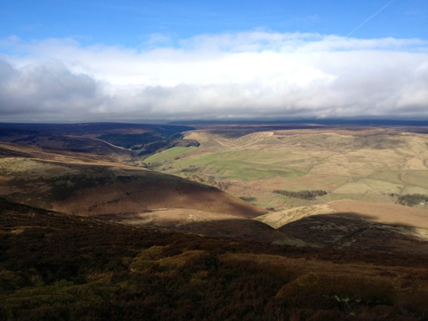
Vale of Edale from Hope Cross
We had originally considered the idea of heading towards Alport Dale and then looping back via Rowlee Pasture. The sight of the deep water rushing across the ford where the Roman Road crosses the River Ashop put us off that plan. We decided to take in a new section of footpath that we hadn’t walked before, we swung back east towards Ladybower and followed the course of the River Ashop Silt Trap.
River Ashop Silt Trap
The walk through Blackley Hey Wood is rather gentle and pleasant. We were certainly ready for a more relaxed wander today as yesterday’s challenge route around the Edale Skyline had taken its toll on our legs a little. It wasn’t long before we reached the banks of Ladybower and begun walking along the forestry track that is also used by anglers. It was a nice coincidence that we ran into a family friend who is a warden with the Ladybower Fisheries who i’d been meaning to drop in on for some time. He had said months ago that I should call in for a coffee if I was ever passing, me being me I had never managed to find the time after a walk.
It wasn’t long before we were weaving around the final few corners and the wall of Ladybower dam came into view. We could almost taste the refreshments at the Yorkshire Bridge Inn as we walked past the Plughole’s and along the wall itself. We quickly chucked our gear in the car and headed to the bar to toast a couple of great days out in the glorious Dark Peak. Thanks for reading and I hope to have more Peak District Wild Camping posts for you very soon.
Having looked at my Dark Peak Combi Map on http://www.shareyouradventure.com I decided I needed to fill in the last remaining space on Kinder Scout, it was the final piece in the jigsaw to make that area of the Peak District look explored. I have walked this way a handful of times in the past but it has been over a year. The last time I walked to this point was when I camped on the eastern edge of Kinder, so I thought it was high time I returned.
We set off at 10am from the Birchin Clough car park on the snake road and headed over to Lady Clough Forest. Lady Clough forest is quickly becoming a new favourite area in the Peak District for both myself and my friend Andy who was with me today. We followed the river down stream to the point where it joins Ashop River and then walked eastward. We followed the rough path along the banks of the river down towards the bridge at OSGB Grid reference SK 1142 9015.
After crossing the bridge over the river Ashop we then had to cross Fairbrook to enable us to pick up the path that rises to Seal Stones. We walked through the sheep pens and then began the rather steep and unrelenting climb of approximately 300metres of accent up to Seal Stones at SK 1137 8886. It’s rather a slog and it get pretty steep towards the end. Not a problem really as Andy and I chatted the whole way up so it was over in a short space of time.
When we arrived at Seal Stones we were at the base of the clouds, We picked our way eastward along the edge of the plateau around to the top of Blackden Brook. The cloud had begun to break at this point and the sun was shinning down on the hills across the Ashop valley and beyond.
The going was good today along Blackden Edge and after negotiating a few boggy patches we arrived at a rock formation near madwoman’s Stone at grid reference SK 1390 8807. We decided it would be a great place to stop for lunch and admire the views while sheltering from the wind. I begun to survey the surrounding area towards the east and it suddenly dawned on me…
In the last 8 months I had climbed to the top of every Hill, walked along every edge and meandered through every valley that I could see. Towards the north I had walked on Bleaklow, then looking clockwise I had stood atop Margery Hill and walked the entire length of the Derwent Edge. I had walked along Stanage and Bamford Edges. I remembered the day I walked the Edale Skyline route and finished upon Win Hill after starting at Lose Hill. I had left no feature unchecked from my list of Peak District achievements. It was at that moment that moment the idea of http://www.PeakRoutes.com took shape. I knew it was high time that I set up a website where I could share all my Peak District routes and experiences… Yes… I already do that on http://www.DeanRead.net but I wanted to create a site that was 100% dedicated to my love of the Peak, it would be my launch pad to promote the joys I have had from walking here. Peak Routes was born 🙂
After our short break for lunch we left the Kinder Plateau and headed down towards Hope Cross, we joined the old Roman Road and headed north west down into the valley. We crossed the ford at SK 1407 8944 and just about managed to keep our feet dry. I’m sure there must have been a bridge over the water here at some point but sadly there isn’t anymore, after periods of heavy rain you would struggle to find a way across the river at this point.
We crossed the road and carried on along the Roman Road. The going was good as we climbed out of the valley away from Hayridge farm that sits at the mouth of Alport Valley. The views were great along this stretch, back across the valley towards Blackden Edge and Blackden Brook. The Old Roman Road is pretty rough from here onwards. Andy and I spoke about how fascinating it would be to be able to turn back the clock and watch the Roman Army march across the valley. The road keeps rising up and up out of the valley until you eventually begin the descent towards Oyster Clough at SK 1195 9050. A quick hope step and jump over the river then you begin the sharp but short climb up towards the Forest. We stopped once again for a quick break and then continued along across the top edge of the Forest. You eventually begin to descend into the pines and there looks to have been some recent logging work here. Large trees have been removed from the clearing and small saplings have begun to grow in their wake. I had never been in this section of the forest before so it was another first for me today. The path rises and falls as you pass above the Snake Inn, it then descends all the way down to the road. We stuck to the path instead of walking along the road and reached the car park at Birchin Clough.
(function() { var po = document.createElement(“script”); po.type = “text/javascript”; po.async = true; po.src = “http://d15mj6e6qmt1na.cloudfront.net/assets/embed.js”; var s = document.getElementsByTagName(“script”)[0]; s.parentNode.insertBefore(po, s); })();
Another fantastic route which we really enjoyed. The northern edge of Kinder Scout never fails to impress no matter what the weather. Today had been a stark contrast to the conditions we had enjoyed the last time we were here. the cold bite of Winter made way for the mild feel of spring today, it really does feel like winter has gone for another year and the days are gradually drawing out again. Thanks for reading and I will have another blog post for you this time next week when I tackle another new route in the Peak District.